Showing posts with label 25 mile hex. Show all posts

Wednesday, July 14, 2010

World Building: Politics and Macro-economics (Part 1.5)

Establishing the Gold Standard

The Tao of D&D author Alexis' posts on his extremely detailed economic system have been a large influence on my thinking for the economic system in my campaign. In his recent post Let's Try It From The Beginning Again he summarizes his approach. While I'm not interested in the achieving the same level of granularity his system explores, I am fascinated by some of the mechanics he uses. In the comments of his post, I asked,

"How do you define the total gold in the system? Does it include non-circulating coin such as in a dragon's horde or buried beneath the sands of a lost city? If players recover a significant amount of wealth and spend it, do you add it to the system? Do you have any mechanic for varying the amount of gold in the system via loss or new mines?"

His response was,

"I calculate my total gold in the system by the use of the United Nations International Statistics Yearbook 1988, which gives the gold produced for that year as 1,771,000 kg. In comparing 1988 with 1650, research I’ve done suggests that the increase in industrial production during that period increased approximately 50,000% ... giving me a nice, round number with which to divide; so 1,771,000 kg over 500 gives approximately 311,000 oz of gold distributed through my system (I use imperial measurements for my world, so the metric is converted).

I’m not dead sure about those numbers, I don’t have my work in front of me, but it is somewhere around those.

It does not take into account ‘circulating gold,’ which I estimate is 9 times the gold produced in a year ... this based on the principle that 1% of all made or resourced material becomes unusable per month. This doesn’t hold for agricultural goods, obviously, but I overlook that because the system demands as much simplification as possible, and I don’t give a shit. I get around the issue by comparing the total gold produced in one year against the total of everything produced in one year.

(adjusted, of course, for industrial development to 1650)"


I'm particularly impressed with his 1% monthly loss rule which elegantly and simply solves a nagging worry I had about "excess" wealth building up.

But another worry of mine is that while Alexis is conquering his entire world, I'm only taking on an Europe-sized section of mine and I need to develop a system of determining the circulating wealth of this fractional land. I have attempted to solve this problem by determining an average gold production per capita.

I started with some numbers on the Roman economy and picked 9 tons (288,000 ounces) of gold output per year and a population of 50 million which gave me 0.00576 ounces of gold per person a year which I rounded up to 0.006. The average mass of a gold coin I set at 5.7 grams or 0.201061583 ounces giving me 5 GP per ounce.

Now let's look again at domain Lisonne and populate it:
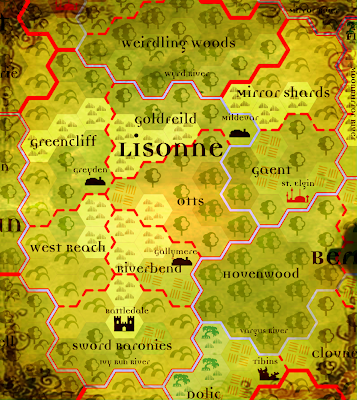


Name Level Population Coin
Gaent 7 60k 18000 gp
Goldfeild 4 10k 3000 gp
Greencliff 5 20k 6000 gp
West Reach 2 4k 1000 gp
Riverbend 6 30k 9000 gp
Mirror Shards 3 7k 2000 gp
Otts 3 7k 2000 gp

The coin column is the amount of hard currency in the province as determined in the last post.

Lisonne has a total population of 138000 people and should have 41000 GPs worth of coin in circulation. But can our gold production numbers support that? Let's find out: 138000 times 0.006 gives us 828 ounces or 4140 GP of yearly gold production. Multiply that by 10 to find the total amount of gold in circulation and we get 41400 GP. Not bad at all! It certainly gives me confidence I'm on the right track.

Next post in this series will detail the actual goods tracked and why, the effect of distance on price, the effects of borders and law level on trade and how I'm setting myself up for coding up some complicated shortest path algorithm in the near future.

Cheers!

Wednesday, June 30, 2010

World Building, Mapping and Population (Part Two)

Birthright Style Provinces...

In the 2e AD&D Birthright campaign settling, political domains such as kingdoms and nations are subdivided into provinces. Birthright provinces are typically about 900 square miles in size and have a maximum population of 100,000 people limited by terrain. Provinces are the smallest unit of land in Birthright 's strategic level of play. They are also a game mechanic abstraction rather than an attempt to closely model a historical entity.

This post is apart of an attempt establish a context between the smaller manor sized holdings player may acquire on beginning Paragon tier (i.e. name level) and the larger holdings on the nation/state level the players should be able to influence by the end of the Paragon tier. (BTW, this system is not edition specific.) In this system, similar provinces will be created with the difference that the target population maximum of each province will be set at 100,000 people and it will be allocated land to support that population. This system will not be slavishly followed, a margin of error up to 15 percent over and 50 percent under is acceptable. (Acceptable to me anyway...) Building on the last post, let's see how we can get to that point.

...on the 25 Mile Hex Scale

From the last post, we established the maximum self-contained population density of our High Middle Ages era culture. It was determined that 750 able-bodied adults could be supported in one 5 mile hex which includes rural and urban dwellers. This assumes that our ideal hex is in a temperate climate and located on fertile land. Let's tackle land first.

First let's define some terrain types:

Plains - are open flat lands well suited to farming.
Deserts - are open flat lands unsuited to farming due to an arid climate.
Badlands - are extremely rough, rocky terrain with poor topsoil and often subject to flash flooding.
Woodlands - are flat lands with light tree cover which does not block sunlight from reaching the surface.
Forests - are flat lands with heavy tree cover whose shade covers the ground layer.
Marshes - are flat low lands near coasts and rivers subject to heavy flooding.
Swamps - are flat low lands with greater expanses of water than a marsh and more tree cover.
Hills - are rocky low land masses extending above the surrounding terrain.
Grassy Hills - are low land masses extending above the surrounding terrain with decent topsoil. They can include tree cover.
Mountains - are high land masses extending above the surrounding terrain. They can include tree cover.
High Mountains - are very high land masses extending above the surrounding terrain. They are above the tree line.

Now let's determine the land available for agriculture:

We are going to assume that each 25 mile hex never really reaches its full population potential. For example, plains are given a maximum of 23 5 miles hexes available for farming rather than 25 to allow for cities or towns and to account for small patches of unsuitable land and land use inefficiencies.

Maximum number of 5 mile hexes available for farming in a 25 mile hex:

Plains, 23
Desert, 2
Badlands, 3
Woodlands, 14
Forests, 10
Marshes, 9
Swamps, 7
Hills, 6
Grassy Hills, 5
Forested Hills, 5
Mountains, 5
Forested Mountains, 2
High Mountains, 1

Of these hexes, there is at least a minimum of 13 of the 25 available 5 mile sub hexes are given over to the primary terrain type. This is true also of the 5 mile sub hexes and the 1 mile sub hexes, etc. (It's hexes all the way down...) The computer programmer in me wants to generate a Ruby script with an randomly variable recursive algorithm which determines land use down to the pebble or until the stack overflows but fortunately I've gotten that sort of thing out of my system elsewhere. I'm setting the modifier statically at .75 for now.

If you're wondering where these numbers came from, it was by a melange of shallow wikipedia research, guesswork and reverse engineering to fit my preexisting map. (In truth, I did have to fix my map in several places.) If you wish to replace these numbers with some other numbers more to you and your maps' liking, you now have a framework with which to get started.

So the maximum population per 25 mile hex looks like this:

Plains: 12937.5 (Probably a halfling...)
Desert: 1125.0
Badlands: 1687.5
Woodland: 7875.0
Forest: 5625.0
Marsh: 5062.5
Swamp: 3937.5
Hills: 3375.0
Grassy Hills: 4500.0
Wooded Hills: 2812.5
Mountains: 2812.5
Wooded Mountains: 1125.0
High Mountains: 562.5

For the sake of example, let's look at the Domain of Lissone, from my DIY campaign world called Moranth:


Lets determine the maximum population of Gaent:

(The Wyrd River is the border between Gaent and Otts if it isn't obvious.)

There four woodland hexes each with 14 5 mile hex farming plots available.
4 * 14 = 56 farm plots

Next we have four plains hexes each with 23 5 mile hex farming plots available.
4 * 23 = 92 farm plots + 56 farm plots = 148 farm plots

Now we have two forest hexes each with 10 5 mile hex farming plots available.
2 * 10 = 20 farm plots + 148 farm plot = 168 farm plots.

Lastly we multiply the 168 farm plots by 750 people and then multiply that by the .75 that represents minor terrain variance.

168 * 750 * .75 = 94500

This is a little under the ideal Provincial maximum population of 100,000 but that's what happens when you draw the map first. ;)

More to come!