In the 2e AD&D Birthright campaign settling, political domains such as kingdoms and nations are subdivided into provinces. Birthright provinces are typically about 900 square miles in size and have a maximum population of 100,000 people limited by terrain. Provinces are the smallest unit of land in Birthright 's strategic level of play. They are also a game mechanic abstraction rather than an attempt to closely model a historical entity.
This post is apart of an attempt establish a context between the smaller manor sized holdings player may acquire on beginning Paragon tier (i.e. name level) and the larger holdings on the nation/state level the players should be able to influence by the end of the Paragon tier. (BTW, this system is not edition specific.) In this system, similar provinces will be created with the difference that the target population maximum of each province will be set at 100,000 people and it will be allocated land to support that population. This system will not be slavishly followed, a margin of error up to 15 percent over and 50 percent under is acceptable. (Acceptable to me anyway...) Building on the last post, let's see how we can get to that point.
...on the 25 Mile Hex Scale
From the last post, we established the maximum self-contained population density of our High Middle Ages era culture. It was determined that 750 able-bodied adults could be supported in one 5 mile hex which includes rural and urban dwellers. This assumes that our ideal hex is in a temperate climate and located on fertile land. Let's tackle land first.
First let's define some terrain types:
Plains - are open flat lands well suited to farming.
Deserts - are open flat lands unsuited to farming due to an arid climate.
Badlands - are extremely rough, rocky terrain with poor topsoil and often subject to flash flooding.
Woodlands - are flat lands with light tree cover which does not block sunlight from reaching the surface.
Forests - are flat lands with heavy tree cover whose shade covers the ground layer.
Marshes - are flat low lands near coasts and rivers subject to heavy flooding.
Swamps - are flat low lands with greater expanses of water than a marsh and more tree cover.
Hills - are rocky low land masses extending above the surrounding terrain.
Grassy Hills - are low land masses extending above the surrounding terrain with decent topsoil. They can include tree cover.
Mountains - are high land masses extending above the surrounding terrain. They can include tree cover.
High Mountains - are very high land masses extending above the surrounding terrain. They are above the tree line.
Now let's determine the land available for agriculture:
We are going to assume that each 25 mile hex never really reaches its full population potential. For example, plains are given a maximum of 23 5 miles hexes available for farming rather than 25 to allow for cities or towns and to account for small patches of unsuitable land and land use inefficiencies.
Maximum number of 5 mile hexes available for farming in a 25 mile hex:
Plains, 23
Desert, 2
Badlands, 3
Woodlands, 14
Forests, 10
Marshes, 9
Swamps, 7
Hills, 6
Grassy Hills, 5
Forested Hills, 5
Mountains, 5
Forested Mountains, 2
High Mountains, 1
Of these hexes, there is at least a minimum of 13 of the 25 available 5 mile sub hexes are given over to the primary terrain type. This is true also of the 5 mile sub hexes and the 1 mile sub hexes, etc. (It's hexes all the way down...) The computer programmer in me wants to generate a Ruby script with an randomly variable recursive algorithm which determines land use down to the pebble or until the stack overflows but fortunately I've gotten that sort of thing out of my system elsewhere. I'm setting the modifier statically at .75 for now.
If you're wondering where these numbers came from, it was by a melange of shallow wikipedia research, guesswork and reverse engineering to fit my preexisting map. (In truth, I did have to fix my map in several places.) If you wish to replace these numbers with some other numbers more to you and your maps' liking, you now have a framework with which to get started.
So the maximum population per 25 mile hex looks like this:
Plains: 12937.5 (Probably a halfling...)
Desert: 1125.0
Badlands: 1687.5
Woodland: 7875.0
Forest: 5625.0
Marsh: 5062.5
Swamp: 3937.5
Hills: 3375.0
Grassy Hills: 4500.0
Wooded Hills: 2812.5
Mountains: 2812.5
Wooded Mountains: 1125.0
High Mountains: 562.5
For the sake of example, let's look at the Domain of Lissone, from my DIY campaign world called Moranth:
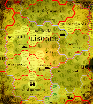
There four woodland hexes each with 14 5 mile hex farming plots available.
4 * 14 = 56 farm plots
Next we have four plains hexes each with 23 5 mile hex farming plots available.
4 * 23 = 92 farm plots + 56 farm plots = 148 farm plots
Now we have two forest hexes each with 10 5 mile hex farming plots available.
2 * 10 = 20 farm plots + 148 farm plot = 168 farm plots.
Lastly we multiply the 168 farm plots by 750 people and then multiply that by the .75 that represents minor terrain variance.
168 * 750 * .75 = 94500
This is a little under the ideal Provincial maximum population of 100,000 but that's what happens when you draw the map first. ;)
Desert: 1125.0
Badlands: 1687.5
Woodland: 7875.0
Forest: 5625.0
Marsh: 5062.5
Swamp: 3937.5
Hills: 3375.0
Grassy Hills: 4500.0
Wooded Hills: 2812.5
Mountains: 2812.5
Wooded Mountains: 1125.0
High Mountains: 562.5
For the sake of example, let's look at the Domain of Lissone, from my DIY campaign world called Moranth:

(The Wyrd River is the border between Gaent and Otts if it isn't obvious.)
There four woodland hexes each with 14 5 mile hex farming plots available.
4 * 14 = 56 farm plots
Next we have four plains hexes each with 23 5 mile hex farming plots available.
4 * 23 = 92 farm plots + 56 farm plots = 148 farm plots
Now we have two forest hexes each with 10 5 mile hex farming plots available.
2 * 10 = 20 farm plots + 148 farm plot = 168 farm plots.
Lastly we multiply the 168 farm plots by 750 people and then multiply that by the .75 that represents minor terrain variance.
168 * 750 * .75 = 94500
This is a little under the ideal Provincial maximum population of 100,000 but that's what happens when you draw the map first. ;)
More to come!

Just found your blog and I have one word: MORE!
ReplyDeleteWith Gaent not reaching it's population intention, wouldn't that lead to a desire for expansion? Or, would that by more prevalent for a region with too many (100,000 or more) inhabitants?
Yep, Hovenwood looks ripe for the picking...
Best,
TB
@The Bane
ReplyDeleteI'm glad you like it! I'm a bit stuck on a problem which is requiring some research right now but more is on the way. I've been trying to think of a subject for a good interim post in the meantime.
94500 is the maximum population of Gaent not the actual population. Currently in my campaign, the actual population of Gaent is about 30000, which is a population level 6 province in Birthright terms so it has room for internal expansion still. 94500 is close enough to a max pop of 100000 to shoe horn it into the Birthright province population chart. The thrust of this post is to come up with a system of standardizing province sizes.
In my campaign, Hovenwood was recently "picked", in fact. (Um, in fiction really...) The realm off this map to the East, The Arch Duchy of Rhys, annexed it and disolved the original realm, The Archduchy of Beres in a rather violent but brief war.
Cheers!
Howdy.
ReplyDeleteI stumbled onto this system by accident and then I began playing with the numbers. I know you were coming up with rough guesstimates to quantify what is going on at the 25mi hex level, which coincidentally is what I'm doing.
My figures aren't adding up and I wanted to share them so that maybe I can either correct my mistake or go with what I've found as being correct.
Going by the Domesday/Medieval Demographics pages, examples are given for population densities:
France - 100 people/square mile (p/sm)
Germany - 90 p/sm
British Isles - 40 p/sm
Crunching numbers, a 25 mile hex is 541.3 square miles.
On S John Ross's page, he gives these figures: "The average population density for a fully-developed medieval country is from 30 per square mile (for countries with lots of rocks, lots of rain, and lots of ice—or a slave-driving Mad King) to a limit of about 120 per square mile, for a land with rich soil, favorable seasons and maybe a touch of magical help. "
Using your numbers, just straight up with none of the lessening due to inefficiencies or land use, you have 750 people/5 mi hex * 25 = 18,750 people/25 mi hex. That leads to a density of ~35 people per square mile - at least in rural/agricultural areas. That seems ... low? If we start using your actual hexes used out of 25 chart, and then drop in the .75 terrain variance, I'm down to ~24 p/sm, which makes those plains in Gaent up there under a really really Mad King. :)
I really like your approach, but I'm thinking about the numbers and if I want to use this approach, and I'm using online tools like the Domesday calculators, I wanted to make things match. Any thoughts?
Later - Aha! Figured it out. My mind wouldn't shut off when I laid down last night, and it hit me.
ReplyDeleteGoing back to your 1 mile/5 mile setup for manors:
"In each of the hexes surrounding it, there is a zone of exclusion in which no other settlement may occupy."
And there you have it. Since 100 people populate a manor which occupies 1 mile hex, but has a 6 hex border, that ultimately limits your population density - using your overlap grapic, your density maxes out at ~35 p/sm.
Is there a mechanical reason for the zone of exclusion or just how you interpreted some source material?
@ChicagoWiz
ReplyDeleteThere are a few things going on to reduce the population density in this system from that found in historical data:
The primary goal of this system is to create a self-consistent game world, not a historical simulation of 13th century Western Europe. (13th century Western Europe was the primary influence of the system, however.) I want a system where can look at population total of a region and quickly determine the number of villages, churches, barbers or cattle, etc in the area. The idea was to build up organically from aggregating simple models rather than trying to reverse engineer real history through unfamiliar and unreliable historical material for a non-historical setting.
Given that the non-historical elements of the setting include dragons, wandering warbands of orcs and magical plagues, it seemed likely human population density would suffer via competition and attrition. Somewhere in my numbers, I have a efficiency coefficient which throttles down the population levels. This plan is to formally tie that to the regions law level to represent control over these outside elements. A higher law level would increase the population cap but I haven't gotten that far yet.
Another buffer in the number is that I'm only counting able bodied economic contributors. For every one population I've counted, add about four more children, infirm, elderly or stay at home spouses, etc. This provides some slop in the system with which to play.
The other decisions to reduce population levels include a general desire for a "points of light" style game setting in which bastions of civilization are fewer and far between. Not so heroic to trek through the wilderness only stumble into someone's backyard every other hex.
The zone of inclusion mechanic was primarily based on modeling an English manor which typically had a mile or so "wastes" surrounding it in which sustainable forestry was practiced. More manors using the same land would deplete the available fuel resources (lumber) and become non-self-reliant, and thus not longer manors but towns or cities. The manors not only need to be self-reliant but exporters of agricultural surplus as well into order to feed the urban populations; they need their space! Cities and town can have much higher densities provide that there are enough nearby manors to feed everyone.
Thanks for your comments!